Research Page
Biosphere Land Carbon Dynamics
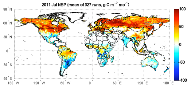
Land vegetation plays an important role in controlling levels of atmospheric carbon dioxide and methane. Globally, terrestrial ecosystems are thought to be contributing ~1.6 TgC/yr to the atmosphere through deforestation and biomass burning, while sequestering some ~2 TgC/yr through forest regrowth, woody encroachment, and growth enhancement mechanisms. However, the future evolution of carbon sources and sinks remains unknown.
Research within the Biospheric Sciences Lab harnesses satellite remote sensing to measure current vegetation carbon stocks and understand their dynamics. Specific focus areas include:
• Producing more accurate estimates of global and regional biomass via lidar and radar remote sensing, using both airborne and satellite platforms.
• Improving estimates of carbon emissions from biomass burning and other disturbances;
• Advancing the ability of ecosystem models to predict current and future carbon fluxes by incorporating available remote sensing datasets;
• Comparing “bottom up” estimates of component land fluxes with “top down” estimates of global atmospheric CO2 and CH4 concentrations from in-situ and satellite data (OCO-2, SCIAMACHY, GOSAT);
• Partnering with national and international organizations to advance the use of remote sensing for monitoring and managing carbon stocks.
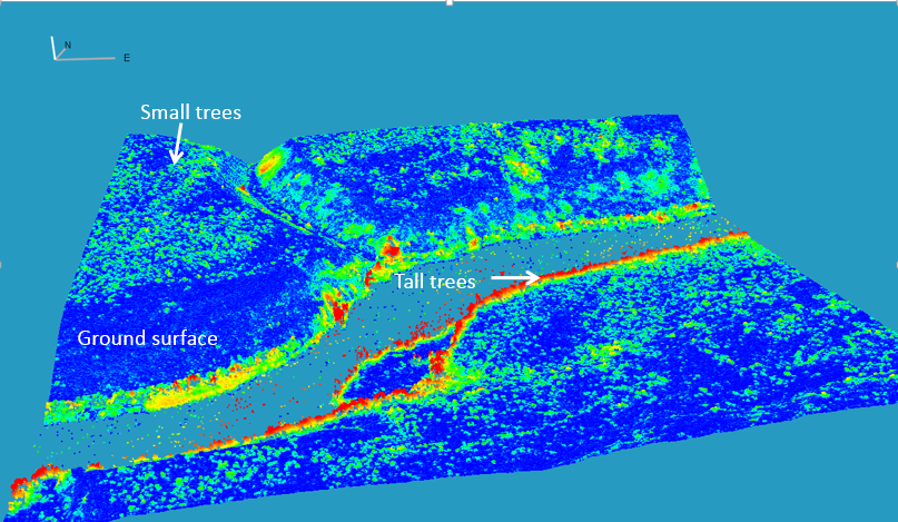
3D View of Canopy Height Model from WorldView Stereo Image (Courtesy Chris Neigh, Jon Ranson)
Areas of Investigation
Circum-Arctic Biomass Mapping (J. Ranson / C. Neigh)
Alaska Carbon Monitoring (D. Morton / B. Cook)
Global Fire Emissions Database – GFED (G.J. Collatz)
Tropical Carbon Emissions (D. Morton)
Forest Biomass from High-Resolution Imagery (C. Neigh)
Research within the Biospheric Sciences Lab harnesses satellite remote sensing to measure current vegetation carbon stocks and understand their dynamics. Specific focus areas include:
• Producing more accurate estimates of global and regional biomass via lidar and radar remote sensing, using both airborne and satellite platforms.
• Improving estimates of carbon emissions from biomass burning and other disturbances;
• Advancing the ability of ecosystem models to predict current and future carbon fluxes by incorporating available remote sensing datasets;
• Comparing “bottom up” estimates of component land fluxes with “top down” estimates of global atmospheric CO2 and CH4 concentrations from in-situ and satellite data (OCO-2, SCIAMACHY, GOSAT);
• Partnering with national and international organizations to advance the use of remote sensing for monitoring and managing carbon stocks.
3D View of Canopy Height Model from WorldView Stereo Image (Courtesy Chris Neigh, Jon Ranson)
Areas of Investigation
Circum-Arctic Biomass Mapping (J. Ranson / C. Neigh)
Alaska Carbon Monitoring (D. Morton / B. Cook)
Global Fire Emissions Database – GFED (G.J. Collatz)
Tropical Carbon Emissions (D. Morton)
Forest Biomass from High-Resolution Imagery (C. Neigh)